At the dawn of World War I, the Krakow Fortress was administratively divided into eight defence perimeters. The first and second defence perimeters were the cities of Krakow and Podgórze, separated by the Vistula River. The natural boundaries of the other defence perimeters, determined by terrain and tactics, were watersheds. In the north, the third perimeter stretched from Vistula to Rudawa, the fourth from Rudawa to Bialucha, the fifth from Bialucha to Dlubnia, and the sixth from Dlubnia back to Vistula. In the south, the ring of fortifications reached east to west towards the Vistula, divided into two defensive circuits along the Wilga Valley.
The outbreak of the war interrupted the expansion and modernization of the permanent fortifications. Several projects in the fortification ring – for peacetime austerity reasons – were not implemented, causing potential dangerous gaps in the defence. These included the broad valley of the Rudawa River and the blind spot in the valley of the Dlubnia River at the foot of the Krzeslawice hills, the stretched fields of naturally wet meadows along the Drwinia River, and the Viennese tract in the valley of the Wilga River.
Water has been used for centuries as an obstacle, either in its natural state or by artificial means. The means of artificially transforming a watercourse into an obstacle were hydro-engineered structures that created wetlands, blockages (damming) and waterlogging. Since creating such obstacles required a significant amount of time, they were used in field fortifications only under favourable conditions. Given suitable terrain conditions, deluges were one of the cheapest artificial obstacles. Small detachments were enough to defend them and prevent any attempted crossing. A lagoon became an obstacle when its depth reached approx. 1.6 meters.
Preparations for the defence of a fortress includ engineering preparations for the battlefield before the defence line. Eg. to blow up bridges that could facilitate enemy crossing. In 1906, hydraulic structures were designed to create artificial deluges parallel to the front line, strengthening the defence of the aforementioned problematic areas (the valleys of the Wilga, Rudawa, and Dlubnia rivers) as quickly and effectively as possible. The quality of the obstacle were defined in terms of “resistance to assault” – and the flooding, waterlogging and swamping provided a severe impediment to attackers.
For the fortress of Krakow three structures can be identified:
a) damming up of the Wilga River, through the most elaborate set of structures and facilities – the closure with a fortress-like pond weir and a long dam across the river valley (original: Wilga Schleuße, Staudamm a.d. Wilga);
b) flooding of the Rudawa valley in the area between the Rudawa and the Rudawa Mill – an earthen causeway across the valley and an earthen irrigation canal connecting the two watercourses (original: Rudawa Inundationsdamm);
c) damming the waters of the Dlubnia River by improvised blocking of the bridge clearance with concrete abutments (original: Dlubnia Stauanlage).
The concrete and stone structure weir Wilgaschleuße was most likely built in the spring of 1915. The weir – unique, the only one in the Krakow Fortress – was part of a larger, approx. 200 m long hydraulic structure, a stone-earthen dam (original: Staudamm). It was used to dam up water in the Wilga valley, to transform the river and the nearby millpond into an obstacle in the foreground of the fortress ring.
| GoogleEarthLink |
Active defence of this section was provided by infantry positions, covered by anti-shrapnel canopies: VII/q 1-3, VII/r 1-3 “Swoszowice” and VII/s 1-4 “Wilga” on the southern bank of the Wilga River, and VIII/a 1-2 on the northern bank. Their tactical tasks were to affect the basin of land near Sosienka and the Wilga valley, to shoot through the valley, a swampy wetland, up to the nearby Swoszowice railroad station . In their vicinity was a strip of wire obstacles. Part of the flooded area was also in the artillery fire sector of the outermost armoured turret of Werk Jugowice.
The planned manning was 370 infantrymen, and 18 artillerymen operating six machine guns. The field positions were visited after their construction by Archduke Karl Franz Josef, later Charles I of Austria in 1915.
The field fortifications were abandoned before the end of the war, and the weir was most likely demolished not much later, as it caused problems for the agricultural use of the Wilga Valley.
To this day, only relics of the weir’s bottom on the Wilga River have survived – fragments of a concrete apron and a short section of ditch and embankment legible. Interestingly, the areas planned for flooding in 1914 still appear on contemporary maps of flood risk and potential floodplains.
Deutsche Zusammenfassung:
Zu Beginn des Ersten Weltkriegs war die Krakauer Festung in acht Verteidigungsbezirke aufgeteilt. Natürliche Gegebenheiten wie Flüsse und Gelände bildeten die Grenzen der Verteidigungsbezirke. Finanzielle Einschränkungen und dann der Kriegsbeginn stoppten die Ausbau- und Modernisierungspläne der permanenten Festungsanlagen und führten zur Nichtumsetzung einiger Projekte, wodurch kritische Lücken entstanden. Hier griff man provisorishc auf eine altes Verteidigungsmittel nämlich der Schaffung von Überflutungsbereichen zurück.
Drei Strukturen wurden in der Krakauer Festung identifiziert: Aufstauung des Wilga-Flusses, Flutung des Rudawa-Tals und Aufstauung des Dlubnia-Flusses. Eine Wehr namens Wilgaschleuße wurde 1915 gebaut. Infanteriepositionen verstärtkten die hydraulische Strukturen. Die Befestigungen wurden nach dem Krieg aufgegeben, das Wehr abgerissen. Einige Überreste sind heute noch sichtbar, und die geplanten Überschwemmungsgebiete sind auf modernen Karten verzeichnet.
-
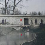
- Photo from the time of the weir’s construction/ Foto aus der Errichtungsphase der Schleuse: 1) Average water level in the Wilga River/ durchschnittlicher Wasserstand der Wilga; 2) the weir wall with a culvert opening/ Staumauer mit Schleusenöffnung; 3) earth and stone dam blocking the river valley/ Erd- und Steindamm zum Abschluss des Tales
-

- 1) The meanders of the Wilga River/ meandrierende Wilga; 2) the milling stream/ Mühlbach; 3) location of the weir/ Schleuse; 4) rocade road/ Rokadeweg; 5) linking the Swoszowice and Jugowice forts/ verbindet die Werke; 6) infantry field fortifications/ Infanteriestützpunkte
-

- 1) Wilga River/ Fluss Wilga; 2) remains of the protective apron plate/ Reste der schützenden Schürzenplatte; 3) concrete wall of the abutment/ Betonwand des Widerlagers